|
|
The Day the Dam Burst.
Just 36 years ago, the mighty St. Francis dam collapsed, loosing a 125-foot wall of water that drowned a sleeping California valley.
Popular Science magazine | March 1964.
|
Last December, the Baldwin Hills dam in Los Angeles broke and sent millions of gallons of water cascading through the city, leaving three persons dead and thousands homeless. It was the worst fiood disaster in the area since the St. Francis dam burst in northwestern Los Angeles county, killing 450 people. POPULAR SCIENCE this month presents a dramatic account of the earlier disaster — which spurred the passing of legislation that was to prevent such catastrophes from ever happening again. But one did, and once again a ravaged community can only ask: Why did it happen?
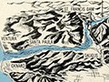
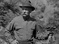
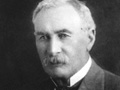
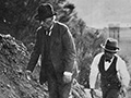
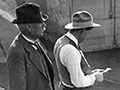
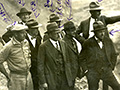
Under a star-bright sky, in the hour before dawn on March 13, 1928, a U.S. Navy cruiser was slicing southward through the tranquil waters of Santa Barbara Channel. The vessel's course for Long Beach took it within 10 miles of the California coast between Ventura and Oxnard. Suddenly, the lookout shouted, "Wreckage dead ahead!" An officer on the bridge quickly ordered the cruiser stopped. As it slid to a halt, searchlights flashed on. Their blue-white beams pointed to a horrifying and wholly mystifying sight. Across the path of the ship lay a broad swath of siltsoiled water. In it floated corpses of horses and cattle, roof tops, trees, barn timbers, and a forlorn stream of household possessions. Here was the unmistakable evidence of a major flood. Yet the cruiser lay off the mouth of a river known to be normally dry. There had been few rains lately. They were never frequent in this locality. Floods were unknown. The cruiser's radio operator urgently queried Long Beach Naval Station. What had happened? No one on duty knew of anything amiss. Communications in 1928 were far less ample than now. On the sleeping mainland, only a few terrified and stricken communities knew the reason for that stain on the clean sea. Yet the worst disaster in the history of Southern California had just occurred. At two minutes before the previous midnight, the big St. Francis Dam, nearly 53 miles inland and 1,700 feet above sea level, had collapsed. The downward rush of water toward the distant ocean took the lives of about 450 persons. Thirty-six years later, the complete count is still not known, and never will be. Six hundred homes had been demolished. As many more had been damaged. Eight thousand acres of productive land had been laid waste. Unnumbered herds of livestock and flocks of poultry had been killed. The cost of destruction was estimated to be at least $10 million. The St. Francis Dam, in northwestern Los Angeles County, was less than two years old. It had been among the most impressive structures of its kind in the U.S. Its concave bulwark, containing 137,000 cubic yards of reinforced concrete, rose 205 feet above the narrow stream bed in San Francisquito Canyon. Its crest line measured 700 feet. An extension stretched 500 feet farther along the west slope of the canyon. The dam was 180 feet thick at its base, 16 feet thick at its top. Behind it, a few minutes before midnight on March 12, lay a four-mile reservoir of the Los Angeles Water & Power Dept. The reservoir, impounding water brought south 250 miles by aqueduct from the Owens Valley, was at its highest level. At the moment of catastrophe, the St. Francis Dam held back 12 billion gallons of water. Then, without warning, the dam burst. Its west wing collapsed first, with explosive force. Ten-thousand-ton chunks of concrete the size of bungalows were tumbled as far as three-quarters of a mile by the towering dark wall of water that lunged down San Francisquito Canyon. Gigantic eddies swirled at the foot of the east section of the dam and quickly cut away its foundations. That part of the barrier also broke into chunks, which slumped and lay where they fell. Only the dam's center section, 205 feet high and about 100 feet wide, resisted the tremendous pressures. The canyon immediately below the dam site is steep and narrow and twists sharply for at least a mile. The plunging torrent from the broken dam, rapidly swelling to a flow greater than 500,000 cubic feet per second, reached a depth of 125 feet as it tore at the curves of its tortuous channel. A mile and a half down the canyon, nestled against its east wall, stood Los Angeles' municipal Power Plant No. 2. It was a two-story building of heavily reinforced concrete, containing two 100-ton dynamos. Close by huddled a settlement of 65 persons — plant employees and their families. Five minutes after the dam crumbled, that unwarned community was swept away. The powerhouse, struck by a flood wave that rose even higher than 125 feet, was obliterated as if it had been a tent. Not far below this spot, a few ranches sprawled across the lower canyon. The Saugus substation of the Southern California Edison Co. stood near where the canyon emptied into the valley of the Santa Clara River. The river bed, with only a thin stream trickling down it, ran westward to the sea for 42.5 miles from the point where canyon and valley met. The plunging waters from the breached dam, still 50 feet deep, in half an hour scoured out the contents of the canyon, drowned the substation, and lurched into a huge, devastating right curve as they found the bed of the river. At about this time, a six-man crew of Edison workers — responding to an emergency alarm from Saugus that the y thought involved a fire — raced into the head of the flood in their wire-enclosed Dodge truck and were rolled over and over. Miraculously, they were flung back out of the water and escaped serious injury. The relentlessly spreading flood by now had widened in places to 2½ miles. It swept across ranches, groves of fruit and walnut trees, a tourist camp, and small communities. It smashed and scattered the riverside shacks of Mexican farm laborers. It up rooted oil and natural-gas pipelines, ripped down telephone and transmission lines. It destroyed miles of roads, tore out a stretch of the main inland highway between Los Angeles and San Francisco, and carried away bridges. It cuffed freight cars off sidings, and left railroad track drooping in braids. Seven and a half miles west of the point where the rushing waters foamed out of San Francisquito Canyon, they bore down upon a construction camp of 140 Edison men. The men, of course, were asleep. But the equipment watchman heard the ominous roar swelling out of the darkness, and somehow guessed what had happened. He ran from cabin to cabin, shouting the sleepers into dazed wakefulness, yelling at them to run for the hills. Some escaped, but 80 didn't make it. Among them was the watchman, whose half-buried body was found later in the muck close to camp. The little city of Santa Paula, 38 miles below the burst dam, was roused in time to save most of its inhabitants. Two telephone operators at Newhall, up the valley, spent the night spreading the alarm fast and far. One of them got through to the Santa Paula police at two a.m. The flood struck the town an hour and 10 minutes 1ater. The police had church and fire bells rung, and rode through the city with sirens wailing. They concentrated on warning the district nearest the river, a largely Mexican quarter. Its people were told to get to Teague Heights as fast as they could, but some, perhaps because they only dimly understood English, ignored the warning and stayed where they were — to drown. When the flood wave, now reduced to a height of 25 feet, crashed into the darkened town, 1,500 shivering refugees were watching from the safety of the heights. Under the starlight, they saw the vague shapes of 20 blocks of houses rise like corks and bob to new locations. It was all over before dawn. The first of 3,000 rescue workers reached the desolated valley well ahead of sunrise. Among them were J.R. Deason and fellow members of the Emergency Road Service Dept. of the Automobile Club of Southern California. Deason, now a supervisor in his department, recently recalled the eeriness of that morning. The valley was dark except for bobbing lanterns moving fitfully in the fields, and silent except for the howling of a clog or two. It was difficult to believe that a tremendous disaster had taken place. Search parties were quietly and quickly organized to look for survivors. Deason will never forget how the flood wave had swept victims over wire fences and then, as it receded, trapped them in the mesh, like fish in a net. And he still remembers freak discoveries: the bodies of six mountain lions — "big ones, too" — and an old-fashioned office safe upright in a meadow, its sides scoured bright by the flood's burden of gravel. By the morning of March 14, the entire nation knew what had happened. Its attention was wrenched from a cavorting stock market to the horror in California. There hadn't been a major U.S. dam disaster since the Johnstown Flood in 1889. Why had the St. Francis Dam burst? The biggest coroner's inquest in the history of Los Angeles County was launched to find out. At the same time, California's Gov. C.C. Young chose four distinguished consulting engineers and two professors of geology to investigate the disaster. At the inquest, 72-year-old William Mulholland, chief engineer of the Los Angeles Water & Power Dept., tearfully testified that he envied the dead. His unblemished reputation of 30 years was in ruins. He took full responsibility for the dam's design and location. This he could scarcely avoid doing. His had been the final approval. "If I were to build St. Francis Dam again, I would build it in the same manner, but not in the same place. That place where it was built was vulnerable against human aggression," he said. Whatever Mulholland meant by his last few words, Gov. Young's expert investigators vividly supported the vulnerability of the site. The location was incredibly unsuitable, it was revealed, because it was subject to water seepage. The design of the dam, the so-called gravity type, was "preeminently safe," the investigators reported. They had tested the material in the dam and found it capable of resisting forces "much beyond any stresses to which it would have been subjected under norm al conditions." "There can be no question," the report continued, " but that such a dam properly built upon a firm and unyielding foundation would be safe and permanent under all conceivable conditions, except perhaps faulting and earthquake shocks of tremendous violence...." There had been no earthquake. "Unfortunately," the investigators wrote, "in this case the foundation under the entire clam left very much to be desired." The rocky cleft of the canyon, which the clam straddled, consisted of an insubstantial mica schist on the east side and an even less substantial reddish conglomerate on the west, the report explained. The two rock formations met, under the west wing of the dam, along a "dead" earthquake fault, ideally designed by nature for seepage. To make matters worse, the conglomerate, "even when dry, was of decidedly inferior strength and ... when wet, became so soft that most of it lost almost all rock characteristics." The probers concluded that "the ultimate failure of this dam was inevitable, unless water could have been kept from reaching the foundation." Instead, they found, water had percolated into and through the area where the schist and conglomerate met, "with resulting softening of the conglomerate under the dam." No eyewitness of the actual break, if there was any, lived to tell what he saw, but Gov. Young's investigators were certain that they knew what had happened: "Either a blowout under, or a settling of the concrete at, this place, or both, occurred, quickly followed by the collapse of large sections of the dam." The commission had one conclusion of overriding importance: "The failure of this clam indicates the desirability of having all such structures erected and maintained under the supervision and control of state authorities." The next session of the legislature wrote the decision into California law. Never again would one individual be the final authority on the safety of any dam of importance. This legal attitude became universal in the United States. In addition, engineering geologists are now on every major dam-building staff, and practical geology is part of every civil engineer's college curriculum. "If the St. Francis Dam were to be rebuilt today," a California engineer told me, "it would probably be an embankment dam, not a gravity dam. That would spread the base over a much greater area and very much lighten the unit load on the foundation. Putting a gravity dam there was rather like resting a woman 's full weight on a spike heel." But the St. Francis Dam has never been rebuilt, though Power Plant No. 2 rose again just where it first stood. San Francisquito Canyon is silent as a cemetery at the old dam site today. Appropriately so, for it still contains memorials to the disaster that occurred there 36 years ago. The dry stream bed is littered with rounded fragments of concrete. Protruding ends of reinforcing rods, twisted like string, testify to the terrible strength of the water that hurled them there on that long-ago night in March.
Download pdf and separate page images here.
|
SEE ALSO:
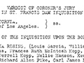
Transcript of Coroner's Inquest
Hall of Justice 1928
Verdict of Coroner's Jury
Arizona Report 1928
Popular Science 1964
• Rippens Story of Dam Disaster (1998)
Vital Lesson for Today (ASDSO 2018)
At Dam Site 3-14-1928
With Van Norman at Dam Site 3-15-1928
Coroner's Jury Inspects 3/1928
Hall of Justice 1928
Fountain 1940s
Aqueduct Memorial Garden Opens at Mulholland Fountain: Story 10-23-2013
Mulholland Fountain & Aqueduct Garden: Photo Gallery 11-10-2013
|


The site owner makes no assertions as to ownership of any original copyrights to digitized images. However, these images are intended for Personal or Research use only. Any other kind of use, including but not limited to commercial or scholarly publication in any medium or format, public exhibition, or use online or in a web site, may be subject to additional restrictions including but not limited to the copyrights held by parties other than the site owner. USERS ARE SOLELY RESPONSIBLE for determining the existence of such rights and for obtaining any permissions and/or paying associated fees necessary for the proposed use.
