|
|
St. Francis Dam: Valencia Mall Area
St. Francis Dam Disaster
[Full View][Closeup of Field][Closeup of Newhall Men]
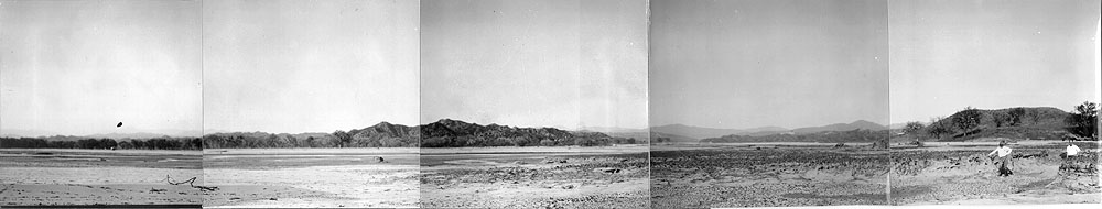
Photo No. 7 from The Newhall Land and Farming Co.'s March 24, 1928 report on the March 12-13 St. Francis Dam Disaster. Photograph showing the general vicinity of today's Valencia Town Center mall. According to the text, this photograph "is a panoramic view taken at a point about 1,000 feet directly south of the point of the promontory that defines the southeastern boundary of San Francisquito Canyon, and if you will study this view carefully commencing at the right-hand you will first note the very deep gullies, in one of which Messrs. E.W. and Geo. A. Newhall, Jr. are standing. Then continuing around from the north to northwest you will note the wide wash up San Francisquito Canyon; thence to northwest, west northwest and west you will observe the absolute destruction of this field by the flood waters.Original caption by Almer M. Newhall reads as follows:
No. 7 Santa Clara Field
From Plate III.
[ RETURN TO TOP ]
[ RETURN TO MAIN INDEX ]
[ PHOTO CREDITS ]
[ BIBLIOGRAPHY ]
[ BOOKS FOR SALE ]
SCVHistory.com is another service of SCVTV, a 501c3 Nonprofit • Site contents ©SCVTV
The site owner makes no assertions as to ownership of any original copyrights to digitized images. However, these images are intended for Personal or Research use only. Any other kind of use, including but not limited to commercial or scholarly publication in any medium or format, public exhibition, or use online or in a web site, may be subject to additional restrictions including but not limited to the copyrights held by parties other than the site owner. USERS ARE SOLELY RESPONSIBLE for determining the existence of such rights and for obtaining any permissions and/or paying associated fees necessary for the proposed use.
The site owner makes no assertions as to ownership of any original copyrights to digitized images. However, these images are intended for Personal or Research use only. Any other kind of use, including but not limited to commercial or scholarly publication in any medium or format, public exhibition, or use online or in a web site, may be subject to additional restrictions including but not limited to the copyrights held by parties other than the site owner. USERS ARE SOLELY RESPONSIBLE for determining the existence of such rights and for obtaining any permissions and/or paying associated fees necessary for the proposed use.
