|
|
Arroyo Southwestern Toad
Endangered Species
[Click here for more endangered & threatened species]
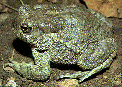
Common Name: Arroyo Southwestern Toad Scientific Name: Bufo microscaphus californicus
Status: Endangered
Federal Register: 59 FR 64866 (Dec. 16, 1994)
Comments: A variant of more common toads, the arroyo Southwestern toad is fairly small, 2 to 3 inches in length, and lives exclusively in Southern California and northern Baja. Historically is was found in coastal drainages from San Luis Obispo County to northern Baja, but urbanization and dam construction in the early 1900s diminished the population, and they now survive primarily in the headwaters in small, isolated populations, preferring sandy stream terraces thick with cottonwoods, oaks or willows and almost no surrounding grassland. It is unclear if any examples have been found in the Santa Clarita Valley, but their habitat includes several local stream- and riverbeds.
The following is from the USDA Forest Service, for the Cleveland National Forest (similar information specific to the Angeles National Forest is not available):
Status and Distribution (Date listed; critical habitat; include % of populations or % habitat): The arroyo southwestern toad was federally listed as endangered in 1994 (USFWS 1994). The entire range of the arroyo toad in the United States is within or near the assessment area. The species also extends down into Baja California, Mexico.
Arroyo toad populations on the Cleveland National Forest and surrounding lands are more numerous, but many appear to be small in size. Most of the populations occur right along the forest boundary with the bulk of prime breeding habitat often lying just off national forest system land. This is the case at Cottonwood Creek which includes lower reaches of Kitchen and Morena creeks, Potrero Creek, the Sweetwater River, the upper San Diego River, Santa Ysabel Creek and associated lower reaches of Temescal Creek (Pamo Valley), the upper forks of the San Luis Rey River (above Lake Henshaw) including Agua Caliente Creek, Temecula Creek including lower reaches of Arroyo Seco Creek, San Mateo Creek, San Juan Creek, and Trabuco Creek. One population that is predominantly on national forest system land occurs along Pine Valley Creek and several of its tributaries.
Recovery Plan (“none” or citation & list of objectives specific to National Forest Service lands): Recovery Plan completed July 1999. U.S. Fish and Wildlife Service. 1999. Arroyo Southwestern Toad (Bufo microscaphus californicus) recovery plan. U. S . Fish and Wildlife Service, Portland, Oregon. Vi+1 l9pp.
Suitable Habitat Definition (from species screens, BAs, etc.; include timing & degree of” detectability”): Typically second order or greater streams between sea level and 4,500 feet elevation within the southern province. Breeding habitat usually consists of shallow (4-8 inch deep) quiet poois with little or no detectable current and gradients between 0-2% slope. Substrate varies from sandy bottoms to mixed small gravel to more hardpan stream bed with little sediment evident Flood terraces and other upland streamside habitats are important for foraging and overwintering sites (fig 4.10). Arroyo toads have been detected up to one kilometer from a water course (Holland and Goodman 1998). Many arroyo toad populations occur along streams that do not normally flow year-round. The largest populations tend to occur in broad floodplains along wide, shallow streams. However, arroyo toads do exist in some small ephemeral drainages (e.g., Indian Flats area, Cleveland National Forest). It is a low-elevation species, with known locations extending from sea level to about 4,400 feet.
Population Levels & Trends on NFS lands (include intensity & extent ofpast survey efforts, protocols used, & expectation for additional populations to be found): Populations have been stable.
Threats (from Listing Package, M&FA, New Information, Recovery Plan, PDCs, etc; focus on threats on NFS lands; include whether threats are increasing or decreasing): Threats to the arroyo toad: Loss of habitat to urbanization and other land use changes such as dams and reservoirs, sand and gravel mining, military operations, recreational uses on public lands. Predation and disease from exotic species such as bullfrogs, crayfish, catfish, sunfish. Also habitat loss to exotic plant invasions in riparian areas by tamarisk and arundo donax. Some collecting by children and losses to trespass use of channels by OHV/ORVs; suction dredging; unnatural water diversions and releases from reservoirs, and loss from crushing by vehicular use of steam crossings and roads immediately adjacent occupied toad habitat provide the majority of impacts.
Protection of Occurrences / Degree of Risk to Occurrences on NFS lands (qualitative & quantitative; include # occurrences in roadless, wilderness, RNAs, etc. (GIS)):
Forests have undertaken a variety of actions including:
- Installation of educational signing.
- Installation of temporary fencing or other barriers to protect breeding sites.
- Limited area-season closures.
- Complete use or entry closures in some areas.
- Closures of access roads >2 miles back from occupied breeding sites.
- Closures and monitoring of high use developed recreation sites.
- Closures of all or portions of grazing allotments.
- Seasonal or complete closures of limited areas to mining activities in streams.
- Educational briefings of local employees to help identify species and better understand concerns with certain uses.
Degree to which NFS lands can contribute to recovery (refer to M&FA App A. Table A): NFS lands could contribute significantly to the recovery of the Arroyo Toad.
Conservation Considerations (e.g., monitoring, minimization/avoidance, management, timing of activities, restoration, etc.):
The primary conservation measures the Forests can undertake include:
- complete surveys of all modeled habitat to determine suitability and occupancy;
- added educational programs;
- acquisition of private inholdings identified as essential habitat;
- continued implementation and effectiveness monitoring of high use sites is also needed to ensure that corrective actions are working;
- exotic species eradication programs aimed at key habitat areas for the toads.
Arroyo toad populations are localized and face a variety of threats. Many populations lie immediately below major dams. The manner in which water is released from upstream reservoirs can greatly influence arroyo toad reproductive success (Sweet 1992) (see “Effect of Dams” section, chapter 3). Recent coordination between various government agencies resulted in releases from Pyramid Dam that more closely mimic natural flows in lower Piru Creek (Sweet 1992). The modified releases have benefited arroyo toads in that drainage (USFWS 1 999a).
Predatory, non-native species are a major threat to arroyo toads. Bullfrogs have been observed to eat juvenile and adult arroyo toads (Sweet 1993). A number of warm-water fishes (e.g., green sunfish, bluegill, largemouth bass, and black bullheads) and crayfish have been shown to feed on arroyo toad larvae and can cause high larval mortality in breeding pools (Sweet 1992). These species occur in many of the streams occupied by arroyo toads (see “Invasive, Non-Native Species” section, chapter 3). In areas close to human development, Argentine ants have spread into riparian areas and are reducing the native ant fauna (Ward 1987, Holway 1995). Native ants are a major food source for arroyo toads; thus, they may be negatively affected by the continued spread of Argentine ants.
Introduced plants are also a problem in some areas. Tamarisk and arundo colonize newly created flood terraces and can form dense masses of vegetation. These dense stands have higher rates of evapotranspiration than do native vegetation, thereby decreasing the amount of available surface water. They also stabilize stream terraces, which helps to deepen flood channels, resulting in habitat unsuitable for arroyo toads (USFWS 1999a).
Campgrounds and roads within or in close proximity to arroyo toad breeding pools have resulted in toads and their egg masses being inadvertently crushed by vehicle and foot traffic and disturbed by waterplay. There are a number of national forest campgrounds located near arroyo toad breeding habitat- seven on the Los Padres National Forest, four on the Angeles National Forest, and four on the Cleveland National Forest (USFWS 1999a). Seasonal closures and/or restrictions on vehicle access have recently been instituted at some of these campgrounds to reduce impacts (e.g., Beaver, Lion, and Mono campgrounds on the Los Padres and Joshua Tree Campground on the Angeles). Road crossings in toad habitat are also being evaluated and several on the Los Padres and Cleveland have been relocated or rebuilt to reduce impacts to breeding pools.
Off-highway vehicle (OHV) activity in arroyo toad habitat is a problem in some areas, particularly on desert-side streams (e.g., Little Rock Creek, Mojave River, upper Piru Creek). Most of the OHV-related habitat damage, at least on national forest system lands, is the result of unauthorized travel off of designated routes into areas legally closed to such use; it is the actions of a few irresponsible individuals and represents a challenging law enforcement problem.
Livestock grazing in arroyo toad habitat can cause trampling of toads and their egg masses. It also can result in degradation to sand bars and terrace habitats that are important to arroyo toads (USFWS 1 999a). Over the last ten years, most riparian habitat on the southern California national forests has been formally excluded from grazing. However, many areas are intermingled with private lands where riparian grazing still exists. Maintenance of fence lines to prevent cattle movement onto public portions of the riparian corridor is a management problem in some areas occupied by arroyo toads.
Suction dredge mining and streamside prospecting (see descriptions of these activities in “Mining” section, chapter 4) have the potential to cause impacts in several areas. Suction dredging has occurred on Piru Creek on the Los Padres National Forest and Pine Valley Creek on the Cleveland National Forest (USFWS 1999a). Prospecting activities, including the digging of pits in the stream bed and banks, has occurred on Little Horsethief Creek on the San Bernardino National Forest (USFWS 1999a). Drawdown of surface water from wells is also a concern.
Survey Considerations (FWS protocol; proposed FS methods for future survey efforts; ability to determine absence, timing, etc.): Utilize FWS survey protocol to determine presence- absence. Surveys should be conducted during the breeding season to maximize the potential for detection of the species and breeding site locations. Negative occupancy results from three or more years of consecutive surveys to protocol should be sufficient to determine unoccupied status of suitable habitat.
The site owner makes no assertions as to ownership of any original copyrights to digitized images. However, these images are intended for Personal or Research use only. Any other kind of use, including but not limited to commercial or scholarly publication in any medium or format, public exhibition, or use online or in a web site, may be subject to additional restrictions including but not limited to the copyrights held by parties other than the site owner. USERS ARE SOLELY RESPONSIBLE for determining the existence of such rights and for obtaining any permissions and/or paying associated fees necessary for the proposed use.
